

$125.00 in Baton Rouge (two two 5)-Nine three 8- one 2 three 4 or PM
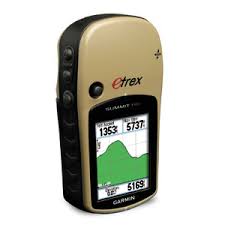
A staple among outdoor enthusiasts, the Garmin eTrex Summit HC Handheld GPS Receiver has a high-sensitivity GPS receiver that offers peak performance in any situation. This handheld GPS includes 24 megabytes of internal memory that lets you store plenty of points, routes, and other details. You can easily identify map details even in bright sunlight with the 256-color, sunlight-readable display.
This Garmin eTrex GPS Receiver also includes a detailed basemap, a barometric altimeter and an electronic compass. The compass provides bearing information even while you're standing still, and the barometric altimeter tracks changes in pressure to identify your exact altitude. Use the altimeter to plot barometric pressure over time - you will be able to keep track of changing weather conditions.
The basemap contains interstates, national and state highways, lakes, rivers, cities, railroads, and coastlines. The automatic track log feature saves nearly 10 tracks, 10,000 points, and helps you navigate back to your starting point. This WASS enabled GPS can be powered by 2 AAA batteries that offer up to 14 hours of run time. It is waterproof, so don't worry about rain or accidental splashes.
Garmin eTrex Summit HC Handheld GPS Receiver 010-00633-001.7" x 1.3" color LCD, 220 x 176 pixels - Presents information in 256 colors
24 MB of built-in memory -Saves additional waypoints and routes from the supplied MapSource Trip and Waypoint Manager software or from optional MapSource mapping products
500 waypoints and 50 routes - Stores your favorite waypoints using names and graphic symbols
Automatic track log - Saves up to 10,000 points and 10 tracks, and TrackBack lets you reverse tracks to navigate back to your starting point
Trip computer - Shows speed, time and distance
WAAS-enabled - Provides DGPS accuracy within three meters
Additional capabilities - Offers an electronic compass, barometric altimeter, hunting/fishing calendar, sun and moon information, area calculation, geocaching mode and outdoor GPS games
Waterproof -Withstands accidental splashes or rain and meets IPX7 standards
Batteries -Works for up to 14 hours on two AA batteries, but no battery is required to maintain stored data
Specifications
| Display Size: | 1.3" x 1.7" |
| Display Type: | 256-color, sunlight-readable display |
| Display Pixels: | 176 x 220 pixels |
| Weight: | 5.5 ounces (156 grams) with batteries |
| Product in Inches: | 1.7 x 1.3 |
| Battery Life: | 14 hrs |
| Routes: | 50 routes |
| Electronic Compass: | Y |
| Two Way Radio: | N |
| Waas Enabled: | Y |
| Built-In Basemap: | Built-in basemap with automatic routing capability |
| Battery Type Required: | 2AA |
| Model #: | 010-00633-00 |
| Multi Pack Indicator: | No |
| Model No.: | 010-00633-00 |
| Shipping Weight (in pounds): | 0.81 |
| Product in Inches (L x W x H): | 1.2 x 2.2 x 4.2 |