
Back in February I started emailing the parish to try to get them to create the Firearm Free Zone map that is required by Louisiana law. At first I got the runaround from parish officials.
"The Parish does not have a “Firearm Free Zone” map. However, I spoke with the St Tammany Parish Sheriff’s Office about your request. They said that the reason there is no map of firearm free zones in the parish is that the areas that allow, or prohibit, firearms are constantly changing. For example; firearms are not allowed in churches where the minister or priest specifically requests that they not be brought inside the church. Certain businesses (restaurants, bars and other public accommodations) post signs at their entrances asking patrons not to bring a weapon inside their establishments. There is no public record of these postings.
The Sheriff’s Office suggested that anyone wanting to know about “carry” and “concealed carry” laws in St Tammany Parish should call the Deputy on Duty at the Parish Sheriff’s Office between 9:00am and 5:30 pm. That phone number is (985) 726-8000. I hope that is helpful."
After explaining to this official that the law has a specific definition of a "firearm free zone" and that definition does not include business, churches, etc., he did not respond to further requests for the map. LA RS 14:95.6
I contacted my councilman, Jake Groby, and explained the situation to him. During our conversation, he insisted that the parish government is not above the law and that if they needed to create this map, he would see to it that this issue was addressed. I forwarded him all the emails I had regarding the map along with the statute number. He called me back the next day and advised that someone within the parish was going to be working on the map. I followed up with him a week later to see if there was an update, at which time he said that the map was being worked on and that he would let me know when he heard something new. Last Friday I received an email from him and also from a Mr. Johnson with the parish saying that the map was ready and could be viewed at the clerk of courts office. It wasn't until yesterday that I was able to get in there to pick up a copy.
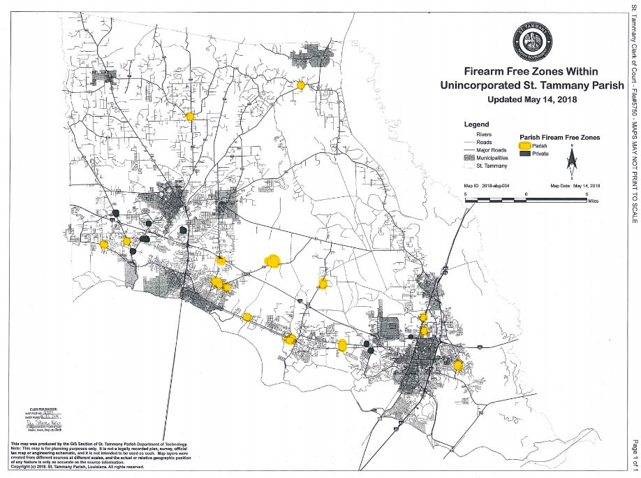
The lady I talked with was very helpful and explained that when scanning the map to make a copy, she had to lighten it so that some features showed up. Being a black and white copy, the light blue circles came out as white circles on the scan. I highlighted the white circles so that they can be found easier. So the white circles on the map represent public schools and the black circles represent private schools. This map only shows schools in unincorporated areas of St. Tammany Parish since that is all that the St. Tammany Parish zoning department has jurisdiction over. Cities like Mandeville and Covington have their own zoning departments and would be responsible for creating their own maps.
If anyone would like to view the map in person, you will need to go to the Justice Center in Covington. If you enter the south entrance, after going through security, go to the Land Records office, first door on the left. Ask for map file 5750. The cost for an 11" x 17" printout is $2.00. I was told that they could also print a 30" x 40" map.
Is this map great? Nope. It's a start though. I am going to follow up with the technology department to see if they can incorporate this on their GIS mapping available online. That would allow a user to zoom in to street level and see a more accurate representation of the 1000' zones.
So here's a link to the map saved as a PDF file. It was too big to attach here, so I saved it on Dropbox. https://www.dropbox.com/s/6v0tovrgiioybrt/5750edit.pdf?dl=0
"The Parish does not have a “Firearm Free Zone” map. However, I spoke with the St Tammany Parish Sheriff’s Office about your request. They said that the reason there is no map of firearm free zones in the parish is that the areas that allow, or prohibit, firearms are constantly changing. For example; firearms are not allowed in churches where the minister or priest specifically requests that they not be brought inside the church. Certain businesses (restaurants, bars and other public accommodations) post signs at their entrances asking patrons not to bring a weapon inside their establishments. There is no public record of these postings.
The Sheriff’s Office suggested that anyone wanting to know about “carry” and “concealed carry” laws in St Tammany Parish should call the Deputy on Duty at the Parish Sheriff’s Office between 9:00am and 5:30 pm. That phone number is (985) 726-8000. I hope that is helpful."
After explaining to this official that the law has a specific definition of a "firearm free zone" and that definition does not include business, churches, etc., he did not respond to further requests for the map. LA RS 14:95.6
I contacted my councilman, Jake Groby, and explained the situation to him. During our conversation, he insisted that the parish government is not above the law and that if they needed to create this map, he would see to it that this issue was addressed. I forwarded him all the emails I had regarding the map along with the statute number. He called me back the next day and advised that someone within the parish was going to be working on the map. I followed up with him a week later to see if there was an update, at which time he said that the map was being worked on and that he would let me know when he heard something new. Last Friday I received an email from him and also from a Mr. Johnson with the parish saying that the map was ready and could be viewed at the clerk of courts office. It wasn't until yesterday that I was able to get in there to pick up a copy.
The lady I talked with was very helpful and explained that when scanning the map to make a copy, she had to lighten it so that some features showed up. Being a black and white copy, the light blue circles came out as white circles on the scan. I highlighted the white circles so that they can be found easier. So the white circles on the map represent public schools and the black circles represent private schools. This map only shows schools in unincorporated areas of St. Tammany Parish since that is all that the St. Tammany Parish zoning department has jurisdiction over. Cities like Mandeville and Covington have their own zoning departments and would be responsible for creating their own maps.
If anyone would like to view the map in person, you will need to go to the Justice Center in Covington. If you enter the south entrance, after going through security, go to the Land Records office, first door on the left. Ask for map file 5750. The cost for an 11" x 17" printout is $2.00. I was told that they could also print a 30" x 40" map.
Is this map great? Nope. It's a start though. I am going to follow up with the technology department to see if they can incorporate this on their GIS mapping available online. That would allow a user to zoom in to street level and see a more accurate representation of the 1000' zones.
So here's a link to the map saved as a PDF file. It was too big to attach here, so I saved it on Dropbox. https://www.dropbox.com/s/6v0tovrgiioybrt/5750edit.pdf?dl=0